Ready to learn about local ecology!
What's this?
River's Park Edge and its partners are pleased to offer all visitors a fun, educational challenge to locate ecological clues thoughout the park.
Learn more
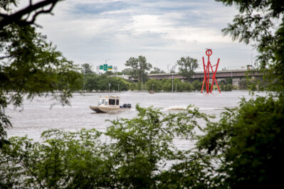
Flooding
Flooding is a natural river event that occurs when a river’s water overflows onto the adjacent land called a floodplain.
See what the Missouri River water level is right now!
Scroll to learn more
Prev NextWhat else can I find?
River's Park Edge is home to many points of interest. But if you found this information interesting, keep seeking out more clues.
Seek for more ecology clues
The Missouri River floodplain was historically comprised of many wetlands that slowed and absorbed flood waters.
Flooding brings nutrient-rich sediment and organic matter to floodplains making them diverse habitats and productive agricultural grounds.
Humans have altered rivers through channelization – straightening, deepening, and confining them – to support commerce and control water flow for human purposes. The Missouri River and many of its tributaries were channelized and their floodplains were drained for farming and urbanization. This change makes rivers fast, narrow, deep, cold, less supportive of their native life, and more susceptible to catastrophic flooding events.
Building in floodplains means assuming risk of flood damage. Investing in flood mitigation strategies is important for anyone living in the floodplain. Some of these strategies are physical structures like levees and green infrastructure such as rain gardens, regional storm water ponds, and restored riparian wetlands upstream of cities. You can help by learning to build your own rain garden, here.
The Missouri River will flood again. It’s smart to be prepared. Learn flood planning steps from the Council Bluffs Levee Program.
Learn more using this interactive flooding map.